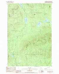
1988 Map of Hay Mountain
USGS Topo · Published 1988About this map
Gulf Hagas cuts a deep path through the southern half of this Maine quadrangle, anchoring a landscape dominated by the timberlands of the North Maine Woods in the late 1980s. The map illustrates the complex township and grant system unique to the region, showing the boundaries of Bowdoin College Grant East and Bowdoin College Grant West alongside unorganized territories like Frenchtown and Shawtown. Higher elevations are marked by West Peak and White Cap Mtn, where the Appalachian National Scenic Trail winds through the high ground. The hydrologic network is dense, featuring the Pleasant River West Branch and a series of remote waters including Big Lyford Pond and the four West Branch Ponds. This era reflects a transition where traditional logging roads provided the primary access to these remote sporting and hiking destinations.
Find a feature on this map
31 named features on this map. Tap any name to fly to it.
Don’t see what you’re looking for? This feature index may not catch every label — zoom into the map to look around manually.
Map Details
Editions of this 1988 Hay Mountain Map
This is the sole edition of this map. No revisions or reprints were ever made.
Other maps of this area

1940 · Sebec
USGS Topo · 1:48,000

1943 · Sebec
USGS Topo · 1:62,500

1950 · Sebec Lake
USGS Topo · 1:62,500

1952 · Jo-Mary Mountain
USGS Topo · 1:62,500

1952 · First Roach Pond
USGS Topo · 1:62,500

1954 · Millinocket
USGS Topo · 1:250,000

1958 · Millinocket
USGS Topo · 1:250,000

1960 · Millinocket
USGS Topo · 1:250,000
1977 · Number Four Mountain
USGS Topo · 1:24,000
1977 · Barren Mountain West
USGS Topo · 1:24,000
Featured Places
- Beaver Cove, ME
- Bowdoin College Grant West Township, ME
- Shawtown Township, ME
- Frenchtown Township, ME
- Bowdoin College Grant East Township, ME