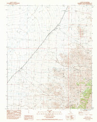
1983 Map of Hayden
USGS Topo · Published 1983About this map
Union Pacific rail lines dominate the western desert landscape of this San Bernardino County survey, tracking north toward the small settlement of Dawes. To the east, the terrain rises sharply into the Providence Mountains, where a concentration of prospects and mine shafts indicates a legacy of mineral exploration within the high country. Resource extraction and water management are the primary human signatures on this arid landscape, evidenced by a series of levees along the tracks and the placement of a Corral near the mountain base.
Find a feature on this map
22 named features on this map. Tap any name to fly to it.
Don’t see what you’re looking for? This feature index may not catch every label — zoom into the map to look around manually.
Map Details
Editions of this 1983 Hayden Map
This is the sole edition of this map. No revisions or reprints were ever made.
Other maps of this area

1910 · Ivanpah
USGS Topo · 1:250,000

1912 · Ivanpah
USGS Topo · 1:250,000

1942 · Ivanpah
USGS Topo · 1:250,000

1942 · Amboy
USGS Topo · 1:250,000

1943 · Amboy
USGS Topo · 1:250,000

1947 · Kingman
USGS Topo · 1:250,000

1948 · Kingman
USGS Topo · 1:250,000

1954 · Needles
USGS Topo · 1:250,000

1954 · Kingman
USGS Topo · 1:250,000

1955 · Kingman
USGS Topo · 1:250,000