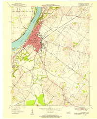
1952 Map of Henderson
USGS Topo · Published 1953About this map
The city of Henderson occupies a prominent position on the southern bank of the Ohio River in the early 1950s, serving as a hub where the Louisville and Nashville and Illinois Central railroads converge. This era shows the community's established social infrastructure through numerous neighborhood institutions like Jefferson Sch and Barret High Sch, alongside the segregated Douglas High Sch. Beyond the urban core, the landscape transitions into a network of drainage ditches such as Sellers Ditch and Elam Ditch, supporting the local agriculture and scattered Oil Wells. The riverside is defined by significant features like Henderson Island and the Audubon Memorial State Park, which preserves the wooded bluffs north of the city. Smaller outlying settlements like Weaverton and Anthoston are linked by thoroughfares including Airline Road, reflecting a region tied closely to its river-and-rail economy.
Find a feature on this map
40 named features on this map. Tap any name to fly to it.
Don’t see what you’re looking for? This feature index may not catch every label — zoom into the map to look around manually.
Map Details
Editions of this 1952 Henderson Map
This is the sole edition of this map. No revisions or reprints were ever made.
Other maps of this area

1905 · Newburg
USGS Topo · 1:62,500

1906 · Sebree
USGS Topo · 1:62,500

1908 · Calhoun
USGS Topo · 1:62,500

1914 · Henderson
USGS Topo · 1:48,000

1916 · Henderson
USGS Topo · 1:62,500

1949 · Poole
USGS Topo · 1:24,000

1949 · Robards
USGS Topo · 1:24,000

1951 · Poole
USGS Topo · 1:24,000

1951 · Robards
USGS Topo · 1:24,000

1951 · Spottsville
USGS Topo · 1:24,000