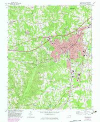
1970 Map of Henderson
USGS Topo · Published 1983About this map
Henderson serves as a bustling commercial and rail hub where the Southern and Seaboard Coast Line railroads intersect. This 1970s record highlights the city's expansion, with distinct neighborhoods like North Henderson and South Henderson flanking the urban core. The surrounding Vance County landscape is dotted with community anchors, from the Harris Chapel and St Andrews Ch to the Oak Grove Sch and Vance Academy. The topography is defined by the drainage of Nutbush Creek and Ruin Creek, while the northern edge of the map shows the controlled waters of the John H Kerr Reservoir.
Find a feature on this map
71 named features on this map. Tap any name to fly to it.
Don’t see what you’re looking for? This feature index may not catch every label — zoom into the map to look around manually.
Map Details
Editions of this 1970 Henderson Map
2 editions found

Other maps of this area

1943 · Creedmoor
USGS Topo · 1:62,500

1944 · Creedmoor
USGS Topo · 1:62,500

1953 · Oxford
USGS Topo · 1:62,500

1953 · Greensboro
USGS Topo · 1:250,000

1954 · Greensboro
USGS Topo · 1:250,000

1962 · Greensboro
USGS Topo · 1:250,000

1966 · Greensboro
USGS Topo · 1:250,000

1966 · Oxford
USGS Topo · 1:62,500

1970 · Vicksboro
USGS Topo · 1:24,000
1970 · Middleburg
USGS Topo · 1:24,000