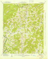
1942 Map of Hepco
USGS Topo · Published 1942About this map
Pisgah National Forest encompasses much of this landscape in western North Carolina, where the borders of Haywood, Madison, and Buncombe counties meet. The 1941 field examination recorded a rural community structure defined by its proximity to water and high ridges, with several small religious and educational centers serving the mountain valleys. Along Fines Creek, local life is anchored by the Fines Creek Sch and Fines Creek Ch, while further north, the Pine Grove Ch and Pine Grove Cem sit near the split in the mountain. The settlement of Hepco lies along the southwestern edge of the map, near the winding path of Pigeon River. Significant elevations like Sandymush Bald and New Found Mountain dictate the drainage patterns of Spring Creek and its many branches, illustrating the difficult terrain that historically isolated these Appalachian highlands.
Find a feature on this map
86 named features on this map. Tap any name to fly to it.
Don’t see what you’re looking for? This feature index may not catch every label — zoom into the map to look around manually.
Map Details
Editions of this 1942 Hepco Map
2 editions found
Other maps of this area

1893 · Mt Guyot
USGS Topo · 1:125,000

1894 · Asheville
USGS Topo · 1:125,000

1901 · Asheville
USGS Topo · 1:125,000

1912 · Mt Guyot
USGS Topo · 1:125,000

1935 · Newport
USGS Topo · 1:48,000

1935 · Canton
USGS Topo · 1:24,000

1935 · Dellwood
USGS Topo · 1:24,000

1935 · Clyde
USGS Topo · 1:24,000

1935 · Spring Creek
USGS Topo · 1:24,000

1935 · Lemon Gap
USGS Topo · 1:24,000