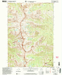
2000 Map of Hilgard Peak
USGS Topo · Published 2005About this map
Hilgard Peak stands as the central landmark of this high-elevation terrain, marking a dramatic divide between the Beaverhead National Forest and Gallatin National Forest. This late 20th-century revision reveals a landscape defined by glacial activity and severe geologic history, encompassing the northern reaches of the Madison River Canyon Earthquake Area. The high basins of the Taylor Hilgard Unit are pocketed with numerous small alpine waters including Thunderbolt Lake, Blue Paradise Lake, and the remote Avalanche Lake at the southern boundary. This map captures the administrative and natural complexity of the Lee Metcalf Wilderness, where names like Expedition Pass and Sentinel Peak reflect a legacy of high-country exploration and surveying. The drainage patterns of Wolf Creek and Beaver Creek illustrate the watershed's significance to the Madison County and Gallatin County line.
Find a feature on this map
53 named features on this map. Tap any name to fly to it.
Don’t see what you’re looking for? This feature index may not catch every label — zoom into the map to look around manually.
Map Details
Editions of this 2000 Hilgard Peak Map
This is the sole edition of this map. No revisions or reprints were ever made.
Other maps of this area

1888 · Three Forks
USGS Topo · 1:250,000

1894 · Three Forks
USGS Topo · 1:250,000

1895 · Three Forks
USGS Topo · 1:250,000

1947 · Bozeman
USGS Topo · 1:250,000

1948 · Bozeman
USGS Topo · 1:250,000

1950 · Cliff Lake
USGS Topo · 1:62,500

1950 · Hebgen Dam
USGS Topo · 1:62,500

1950 · Cameron
USGS Topo · 1:62,500

1950 · Sphinx Mountain
USGS Topo · 1:62,500

1955 · Bozeman
USGS Topo · 1:250,000