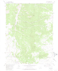
1980 Map of Hillside
USGS Topo · Published 1981About this map
Texas Creek flows through the high terrain along the border of Fremont and Custer counties, defining the topography of this portion of the Wet Mountain Valley. The settlement of Hillside serves as a local anchor, situated near the Hillside Cem and the remnants of an Old Railroad Grade that once navigated the valley floor. The map records a landscape where water and elevation dictate settlement patterns, from the remote Trails End Ranch to the numerous gulches like Stacey Gulch and Rogers Gulch that drain the surrounding heights. Prominent peaks such as Lookout Mountain, Gem Mountain, and Democratic Mountain overlook the drainage systems of Lake Creek and Duckett Creek. Local history and mineral interest are noted by several Prospect sites located near Democratic Gulch, indicating the historical search for resources in these granite-ribbed slopes.
Find a feature on this map
32 named features on this map. Tap any name to fly to it.
Don’t see what you’re looking for? This feature index may not catch every label — zoom into the map to look around manually.
Map Details
Editions of this 1980 Hillside Map
2 editions found
Other maps of this area

1889 · Canon City
USGS Topo · 1:125,000

1892 · Canon City
USGS Topo · 1:125,000

1954 · Pueblo
USGS Topo · 1:250,000

1955 · Westcliffe
USGS Topo · 1:24,000

1957 · Pueblo
USGS Topo · 1:250,000

1958 · Pueblo
USGS Topo · 1:250,000

1958 · Beckwith Mountain
USGS Topo · 1:24,000

1959 · Electric Peak
USGS Topo · 1:62,500

1959 · Royal Gorge
USGS Topo · 1:62,500

1959 · Cotopaxi
USGS Topo · 1:62,500