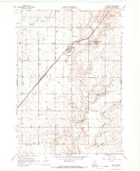
1967 Map of Holland
USGS Topo · Published 1969About this map
Holland serves as the central hub of this Pipestone County landscape, situated where the Great Northern railway cuts diagonally across the prairie. The town's grid is clearly defined, featuring a Sewage Disposal plant and nearby Holland Cem. The surrounding townships of Fountain Prairie, Grange, Aetna, Rock, Gray, and Burke reveal a highly managed agricultural environment, evidenced by the extensive County Ditch system designed to regulate water flow into Pipestone Creek and the Rock River.
Find a feature on this map
22 named features on this map. Tap any name to fly to it.
Don’t see what you’re looking for? This feature index may not catch every label — zoom into the map to look around manually.
Map Details
Editions of this 1967 Holland Map
This is the sole edition of this map. No revisions or reprints were ever made.
Other maps of this area

1953 · Watertown
USGS Topo · 1:250,000

1955 · Sioux Falls
USGS Topo · 1:250,000

1958 · Sioux Falls
USGS Topo · 1:250,000

1958 · Watertown
USGS Topo · 1:250,000

1967 · Pipestone North
USGS Topo · 1:24,000

1967 · Edgerton North
USGS Topo · 1:24,000

1967 · Edgerton NE
USGS Topo · 1:24,000
1967 · Ruthton
USGS Topo · 1:24,000

1967 · Ruthton NW
USGS Topo · 1:24,000
1967 · Woodstock
USGS Topo · 1:24,000