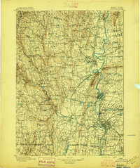
1896 Map of Holyoke
USGS Topo · Published 1896About this map
The Connecticut River serves as the central artery for this late-nineteenth-century landscape, anchoring a dense network of industrial and agricultural hubs. Major manufacturing centers like Florence, Easthampton, and Southampton are well-established, while smaller industrial hamlets such as Loudville and Knightville dot the interior hillsides. The western portion of the map is dominated by the Berkshires' eastern slopes, where scattered settlements like West Worthington and Chester Center are linked by high-elevation roads and rail lines.
Find a feature on this map
177 named features on this map. Tap any name to fly to it.
Don’t see what you’re looking for? This feature index may not catch every label — zoom into the map to look around manually.
Map Details
Editions of this 1896 Holyoke Map
This is the sole edition of this map. No revisions or reprints were ever made.
Other maps of this area

1885 · Northampton
USGS Topo · 1:62,500

1886 · Greylock
USGS Topo · 1:62,500

1886 · Springfield
USGS Topo · 1:62,500

1886 · Hawley
USGS Topo · 1:62,500

1886 · Chesterfield
USGS Topo · 1:62,500

1886 · Northampton
USGS Topo · 1:62,500
1886 · Becket
USGS Topo · 1:62,500

1887 · Warwick
USGS Topo · 1:62,500

1887 · Palmer
USGS Topo · 1:62,500

1887 · Belchertown
USGS Topo · 1:62,500