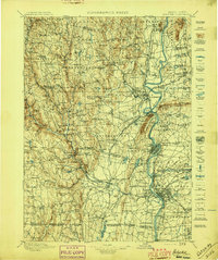
1897 Map of Holyoke
USGS Topo · Published 1897About this map
The Connecticut River serves as the central artery for this late 19th-century landscape, anchoring industrial and agricultural centers from Northampton down to Springfield. The map captures a critical period of development where water power and rail infrastructure intersect, particularly evident at the Ox Bow and the heavy concentration of mills and factories near Holyoke. To the east, the Agricultural College in Amherst signals the region's academic foundations, while the western highlands are defined by small milling hamlets like Bisbee Mill and Ringville situated along the steep gradients of the Westfield River.
Find a feature on this map
226 named features on this map. Tap any name to fly to it.
Don’t see what you’re looking for? This feature index may not catch every label — zoom into the map to look around manually.
Map Details
Editions of this 1897 Holyoke Map
This is the sole edition of this map. No revisions or reprints were ever made.
Other maps of this area

1885 · Northampton
USGS Topo · 1:62,500

1886 · Greylock
USGS Topo · 1:62,500

1886 · Springfield
USGS Topo · 1:62,500

1886 · Hawley
USGS Topo · 1:62,500

1886 · Chesterfield
USGS Topo · 1:62,500

1886 · Northampton
USGS Topo · 1:62,500

1886 · Becket
USGS Topo · 1:62,500

1887 · Warwick
USGS Topo · 1:62,500

1887 · Palmer
USGS Topo · 1:62,500

1887 · Belchertown
USGS Topo · 1:62,500