2023 Map of Hopewell Junction
USGS Topo · Published 2023About this map
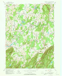
Hopewell Junction sits at the heart of this Southern Dutchess County landscape, where suburban expansion meets the steep terrain of the Hudson Highlands. The map traces the winding paths of Fishkill Creek and Sprout Creek as they move through established hamlets like Brinckerhoff and Wiccopee. This modern survey reveals the complex infrastructure of the region, including the subterranean route of the Delaware Aqueduct and the high-elevation path of the Appalachian National Scenic Trail across Shenandoah Mountain. Genealogists will find significant detail in the numerous burial sites documented, including the Rombout Rural Cem and family plots like the Van Wyck Cem. The transition from the dense residential clusters of Myers Corner and Merritt Park to the wooded slopes of Honness Mountain and Hosner Mountain illustrates the enduring geographic divide between the valley floor and the rocky uplands of the Dutchess and Putnam County border.
Find a feature on this map
42 named features on this map. Tap any name to fly to it.
Don’t see what you’re looking for? This feature index may not catch every label — zoom into the map to look around manually.
Map Details
Editions of this 2023 Hopewell Junction Map
This is the sole edition of this map. No revisions or reprints were ever made.
Historical Maps of Kent Through Time
3 maps found