1962 Map of Indianapolis
USGS Topo · Published 1962About this map
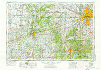
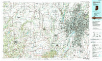
Indianapolis serves as the focal point of this regional study, showing its mid-century urban expansion and the network of radial highways like U.S. 31 and U.S. 40 that connected it to the surrounding heartland. The landscape transitions from the dense street grids of Speedway and Beech Grove to the forested hills of the south, where Brown County State Park and Morgan-Monroe State Forest dominate the terrain. Along the western edge, the Wabash River valley defines the border between Indiana and Illinois, passing through industrial and collegiate centers like Terre Haute, home to Rose Polytechnic Institute. The era's infrastructure is prominently displayed through military installations such as Camp Atterbury and Fort Benjamin Harrison, alongside a dense lattice of railroads including the Pennsylvania RR and New York Central RR. This period captures the region as a major crossroads of higher education and industry before the full realization of the interstate highway system.
Find a feature on this map
425 named features on this map. Tap any name to fly to it.
Don’t see what you’re looking for? This feature index may not catch every label — zoom into the map to look around manually.
Map Details
Editions of this 1962 Indianapolis Map
This is the sole edition of this map. No revisions or reprints were ever made.
Historical Maps of Indianapolis Through Time
5 maps found