Loading...
Loading map...2001 Map of Island of Kosrae
USGS Topo · Published 2004About this map
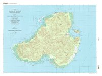
Lelu Island and its adjacent harbor dominate the eastern coastline of this Pacific landscape, serving as a focal point for settlement and maritime activity. The island's interior is defined by sharp elevation changes, culminating in peaks like Mount Finkol and Mount Mutunte. Coastal life is concentrated along the narrow peripheral lowlands, where villages such as Tafunsak and Malem are connected by a perimeter road system.
Find a feature on this map
108 named features on this map. Tap any name to fly to it.
Don’t see what you’re looking for? This feature index may not catch every label — zoom into the map to look around manually.
Map Details
Date Portrayed2001
Date Published2004
PublisherU.S. Geological Survey
Map TypeTopographic
Scale1:25,000
Physical Dimensions35.01 x 25.94 inches
Editions of this 2001 Island of Kosrae Map
This is the sole edition of this map. No revisions or reprints were ever made.
Other maps of this area
No other maps of this area yet.
Featured Places
Source Details
SourceU.S. Geological Survey
CopyrightPublic Domain