2023 Map of Island Park
USGS Topo · Published 2023About this map
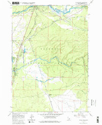
The Island Park vicinity of eastern Idaho is defined by its dramatic volcanic geology and the headwaters of the Henrys Fork. This 2023 survey provides a modern look at the land within the Targhee National Forest, where the historic settlement of Trude sits near the winding course of Elk Creek. The landscape is dominated by the massive Island Park Caldera and the smaller Henrys Fork Caldera, illustrating the complex geologic history of this region. Residential developments like Elk Creek Estates North and the Toms Creek Spur appear alongside significant water bodies including the Buffalo River and Moose Creek. The map also traces the distinct corridor of the Railroad Right-Of-Way Trl, marking the path of former rail lines that once served this high-country basin.
Find a feature on this map
3 named features on this map. Tap any name to fly to it.
Don’t see what you’re looking for? This feature index may not catch every label — zoom into the map to look around manually.
Map Details
Editions of this 2023 Island Park Map
This is the sole edition of this map. No revisions or reprints were ever made.