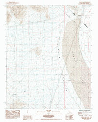
1985 Map of Ivanpah Lake
USGS Topo · Published 1985About this map
Clark Mtn Range dominates the northwestern corner of this map, looking down upon the broad expanse of Ivanpah Valley where California and Nevada meet. This 1980s landscape is defined by the stark transition from the high relief of the mountains to the flat, expansive dry bed of Ivanpah Lake. Evidence of localized resource extraction and water access is scattered across the arid terrain, including the Umberci Mine and a Borrow Pit near the Nevada border. Transport across this desert environment is anchored by Yates Well Road, which leads to the critical water source at Yates Well. The map captures the precise Boundary (1873) and the State Line, illustrating the historical and administrative partitioning of this high-desert region during the late twentieth century.
Find a feature on this map
14 named features on this map. Tap any name to fly to it.
Don’t see what you’re looking for? This feature index may not catch every label — zoom into the map to look around manually.
Map Details
Editions of this 1985 Ivanpah Lake Map
This is the sole edition of this map. No revisions or reprints were ever made.
Other maps of this area

1910 · Ivanpah
USGS Topo · 1:250,000

1912 · Ivanpah
USGS Topo · 1:250,000

1942 · Ivanpah
USGS Topo · 1:250,000

1947 · Kingman
USGS Topo · 1:250,000

1948 · Kingman
USGS Topo · 1:250,000

1954 · Kingman
USGS Topo · 1:250,000

1955 · Kingman
USGS Topo · 1:250,000

1955 · Mescal Range
USGS Topo · 1:62,500

1955 · Roach Lake
USGS Topo · 1:62,500

1956 · Ivanpah
USGS Topo · 1:62,500