Old Maps of Clark County, Nevada
Explore 797 old maps of Clark County, spanning from 1886 to today. These high-resolution historic maps reveal how streets, neighborhoods, landmarks, and natural features evolved over time — perfect for genealogy, metal detecting, research, and local history exploration.
What you can do with these maps:
- See how Clark County changed over time: Compare historical maps to modern-day views to trace roads, homesites, rail lines & more.
- View detailed metadata: Each map includes creators, publishers, year, scale, and archive source.
- Overlay maps with satellite & LiDAR: Visualize the past alongside modern tools to explore terrain & human change.
- Trusted historical sources: Maps sourced from the USGS, Library of Congress, and other archives.
- Access maps your way: View online, download high-res files, or order prints for personal or research use.
Start exploring old maps of Clark County to uncover forgotten places, hidden landmarks, and the deep history beneath your feet.
Clark County, NV maps
(797)- 1886 Map of Camp Mohave
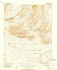
 1886 Camp Mohave1886 Print · USGSThe Colorado River and the Cerbat mining districts define this territory during the mid-1880s. Genealogists and historians can trace the early rail stops at Kingman and Beale, or find the locations of frontier mining camps like Chloride and Mineral Park.
 - 1886 Map of Saint Thomas
 1886 Saint Thomas1886 Print · USGSSoutheastern Nevada's river valleys and early trails are captured here in the late nineteenth century, long before the creation of Lake Mead. Genealogists and historians can locate early settlements like Saint Thomas and Old Callville, and trace river crossings at Stone Ferry and Scanlon Ferry.6 unique versions available
 - 1892 Map of Camp Mohave
 1892 Camp Mohave1892 Print · USGSThe Colorado River frontier in the 1890s reveals a network of isolated mining camps and military outposts. Trace the early river-crossing economy and mining boomtowns through Eldorado Ferry, the Patterson Mine, and the military station at Camp Mohave.8 unique versions available
 - 1893 Map of Saint Thomas
 1893 Saint Thomas1893 Print · USGSSouthern Nevada at the close of the nineteenth century reveals a network of river-based settlements and trails. Genealogists and researchers can trace the early locations of Saint Thomas, Old Callville, and the Stone Ferry crossing.
 - 1907 Map of Las Vegas, 1956 Print
 1907 Las Vegas1956 Print · USGSSouthern Nevada is shown at a pivotal moment in the early 1900s as the rail network began to transform the desert landscape. Genealogists and historians can locate early homesteads and landmarks like Las Vegas Ranch, Mormon Well, and the Stirling Mine.
 - 1908 Map of Las Vegas
 1908 Las Vegas1908 Print · USGSSouthern Nevada was a frontier of rail and ranching in the years before major desert expansion. Trace the early footprints of Las Vegas and its surrounding outposts like Arden, Bracken, and the Stirling Mine.4 unique versions available
 - 1910 Map of Ivanpah, 1957 Print
 1910 Ivanpah1957 Print · USGSThe Mojave high desert at the start of the twentieth century was a landscape of remote mining camps and vital railroad junctions. Trace the early industrial footprint of Vanderbilt, the Copper World Mine, and the rail stops at Nipton and Kelso.
 - 1912 Map of Ivanpah
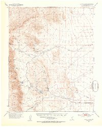
 1912 Ivanpah1912 Print · USGSThe Mojave high desert at the border of California and Nevada was a bustling corridor of mining and transcontinental rail at the start of the century. Genealogists and historians can trace defunct settlements and industrial sites like the abandoned copper smelter, Good Springs, and the Old Traction Road.5 unique versions available
 - 1926 Map of Nelson
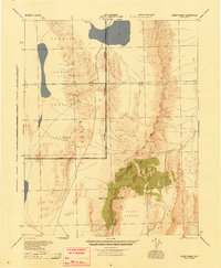
 1926 Nelson1926 Print · USGSThe Colorado River borderlands in the mid-twenties appear here as a landscape of desert canyons and future infrastructure. Researchers can trace the original river course through Eldorado Canyon and locate early sites like Nelson and the Middle Black Canyon Dam Site.
 - 1926 Map of Mohave City
 1926 Mohave City1926 Print · USGSThe Colorado River borderlands in the mid-twenties reveal a landscape of mining claims and early desert ranching before the era of modern dams. Researchers can trace the Arrowhead Trail south from Searchlight and locate family landmarks like the D Hutton Ranch or the Piute mine.
 - 1926 Map of Bonelli
 1926 Bonelli1926 Print · USGSThe Nevada-Arizona borderlands are captured here in the mid-1920s, showing the original river-crossing culture before the landscape was submerged. Researchers can trace the river economy through Bonelli Ferry, the settlement at St Thomas, and local mining at the Calico Salt Mine.
 - 1926 Map of Boulder Canyon
 1926 Boulder Canyon1926 Print · USGSBefore the completion of the Hoover Dam, this 1920s survey documents the Colorado River basin and its burgeoning infrastructure. Researchers can trace early railroad stops at Apex and Garnet, or locate the original Boulder Canyon Dam Site and Bonelli landing.2 unique versions available
 - 1942 Map of Camp Mohave
 1942 Camp Mohave1942 Print · USGSThe tri-state borderlands of Nevada, Arizona, and California are captured here in the early 1940s, highlighting a landscape of deep canyons and high-desert mining camps. Researchers can trace historic rail lines and find remote outposts like Searchlight, Nelson, and the riverfront Fort Mohave Indian Reservation.
 - 1942 Map of Indian Spring
 1942 Indian Spring1942 Print · USGSSouthern Nevada's desert landscape is captured here in the early forties as military interests began to redefine the territory. Researchers can trace the early layout of Indian Spring and find remote water sources like Quartz Spring and Mesquite Spring.
 - 1942 Map of Ivanpah
 1942 Ivanpah1942 Print · USGSThe Mojave Desert frontier comes into focus during the early war years, showing a landscape shaped by mining and rail. You can trace the path of the Union Pacific through remote stops like Nipton, Goodsprings, and the junction at Barnwell.
 - 1945 Map of Sheep Range
 1945 Sheep Range1945 Print · USGSThe Nevada desert in the mid-1940s is shown here as a massive military training ground just after the war. Researchers can trace the Approximate Reservation Boundary of the Tonopah Aerial Gunnery Range and locate landmarks like Sheep Peak and the Yucca Forest.
 - 1947 Map of Kingman, 1948 Print
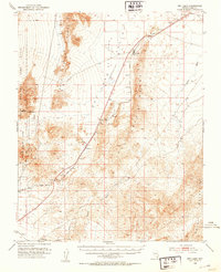
 1947 Kingman1948 Print · USGSThe tri-state Mojave desert region comes into focus during the late 1940s, as post-war travel began to surge along U S 66. Genealogists and historians can trace the mining-and-rail economy through the Atchison Topeka and Santa Fe line, the Copper World Mine, and old settlements like Oatman or Goodsprings.2 unique versions available
 - 1948 Map of Kingman
 1948 Kingman1948 Print · USGSThe Mojave Desert at the dawn of the fifties shows a landscape of deep canyons and booming mines along the Arizona and Nevada border. Genealogists and historians can trace rail-stop towns and mining claims like Oatman, Searchlight, and the Mohawk Mine.
 - 1950 Map of Davis Dam, 1955 Print
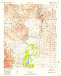 1950 Davis Dam1955 Print · USGSThe Colorado River corridor was undergoing a massive transformation in the early fifties as the newly completed Davis Dam began reshaping the tri-state border. Researchers can trace vanished river landings and frontier outposts such as the Hardyville Site, Mohave City, and the Fort Mohave Ruins.2 unique versions available
 - 1952 Map of Davis Dam
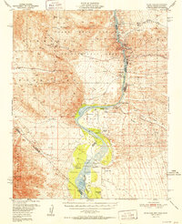 1952 Davis Dam1952 Print · USGSThe Colorado River valley emerges in a period of significant change during the early fifties, as modern infrastructure meets pioneer history. Genealogists and historians can trace family-named locations such as Hardyville Ranch alongside significant landmarks like Fort Mohave (Ruins) and Bullhead City.2 unique versions available
 - 1952 Map of Corn Creek Springs, 1953 Print
 1952 Corn Creek Springs1953 Print · USGSThe northern Las Vegas Valley is captured here in the early 1950s, highlighting the vital water sources and ranching outposts of the Mojave desert. Trace the path of the Dismantled Railroad and locate historic sites like Tule Springs Ranch and Corn Creek Springs.3 unique versions available
 - 1952 Map of Gass Peak, 1953 Print
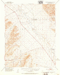
 1952 Gass Peak1953 Print · USGSIn the early fifties, the high desert north of Las Vegas was becoming a critical zone for national defense and conservation. You can trace the expansion of Nellis Air Force Base alongside historic water sources like Mormon Wells and the June Bug Mine.4 unique versions available
 - 1952 Map of Blue Diamond, 1953 Print
 1952 Blue Diamond1953 Print · USGSBlue Diamond and the surrounding Nevada desert appear here in the early fifties during a period of active quarrying and ranching. Genealogists and historians can trace family-named outposts like Bar Nothing Ranch or Oliver Ranch and locate early industry at the Blue Diamond Mine.5 unique versions available
 - 1952 Map of Dry Lake, 1953 Print
 1952 Dry Lake1953 Print · USGSRailroad and highway travel through the southern Nevada desert dominated the landscape in the early fifties. Local historians can trace the infrastructure of the Union Pacific line and small settlements like Crystal, Arrolime, and Dry Lake.2 unique versions available
 - 1952 Map of Henderson, 1956 Print
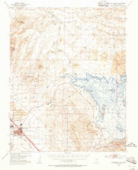 1952 Henderson1956 Print · USGSHenderson and the shores of Lake Mead are shown here in the early fifties during an era of significant industrial expansion. Researchers can trace the layout of worker housing at Victory Village and Carver Park or locate the sprawling Magnesium Plant and Three Kids Mine.2 unique versions available
Showing maps 1-25 of 797
Top cities of Clark County
- Las Vegas historical maps
- Henderson historical maps
- North Las Vegas historical maps
- Enterprise historical maps
- Spring Valley historical maps
- Sunrise Manor historical maps
See more
Frequently asked questions
- What are the different types of historical maps available for Clark County?
- What is the oldest map of Clark County?
- Where can I purchase historical maps of Clark County for my home or office?
- Where can I download high-res historical maps of Clark County?
- Are there historical topographic maps available for Clark County?
- Is there historical aerial imagery available for Clark County?
- Where are historical maps of Clark County sourced from?