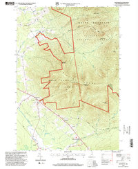
1995 Map of Jefferson
USGS Topo · Published 2000About this map
The Jefferson township and the high peaks of the Pliny Range dominate this mid-1990s topographical survey of northern New Hampshire. Settlement is concentrated along the river valley floor, where the Israel River and its many tributaries, such as Caleb Brook and Garland Brook, carve through the landscape. The map captures the interface between the village centers of Starr King and Jefferson Highland and the sprawling wilderness of the White Mountain National Forest. While the high elevations are defined by summits like Mount Waumbek and Mount Starr King, the valley preserves local history through the Jefferson Cemetery and Forest Vale Cemetery. Transport and recreation are visible in the network of rural routes like Pleasant Valley Road and the extensive hiking paths including the Kilkenny Ridge Trail, reflecting an economy balanced between forestry, small-scale industry at the Gravel Pit, and mountain tourism.
Find a feature on this map
48 named features on this map. Tap any name to fly to it.
Don’t see what you’re looking for? This feature index may not catch every label — zoom into the map to look around manually.
Map Details
Editions of this 1995 Jefferson Map
This is the sole edition of this map. No revisions or reprints were ever made.
Other maps of this area

1893 · Mt. Washington
USGS Topo · 1:62,500

1896 · Mt. Washington
USGS Topo · 1:62,500

1900 · Whitefield
USGS Topo · 1:62,500

1920 · Guildhall
USGS Topo · 1:62,500

1930 · Percy
USGS Topo · 1:62,500

1931 · Guildhall
USGS Topo · 1:48,000

1933 · Guildhall
USGS Topo · 1:48,000

1934 · Percy
USGS Topo · 1:62,500

1935 · Whitefield
USGS Topo · 1:48,000

1935 · Mt. Washington
USGS Topo · 1:62,500