1947 Map of Jersey City
USGS Topo · Published 1947About this map
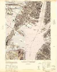
Industrial waterfronts and massive rail yards define this 1947 portrait of the harbor, where the Hackensack River and Passaic River meet at Newark Bay. The landscape is dominated by the logistics of the era, from the sprawling Meadows Yard to the Lehigh Valley Freight Sta. These transit hubs supported a dense urban grid in Jersey City and Hoboken, connected to Manhattan via the Holland Vehicular Tunnels and the Exchange Pl Sta.
Find a feature on this map
87 named features on this map. Tap any name to fly to it.
Don’t see what you’re looking for? This feature index may not catch every label — zoom into the map to look around manually.
Map Details
Editions of this 1947 Jersey City Map
This is the sole edition of this map. No revisions or reprints were ever made.
Other maps of this area

1888 · Paterson
USGS Topo · 1:62,500

1889 · Brooklyn
USGS Topo · 1:62,500

1891 · Brooklyn
USGS Topo · 1:62,500

1891 · Harlem
USGS Topo · 1:62,500

1892 · Paterson
USGS Topo · 1:62,500

1897 · Harlem
USGS Topo · 1:62,500

1897 · Brooklyn
USGS Topo · 1:62,500

1898 · Harlem
USGS Topo · 1:62,500

1898 · Staten Island
USGS Topo · 1:62,500

1898 · Brooklyn
USGS Topo · 1:62,500