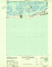
1947 Map of Jones Inlet
USGS Topo · Published 1947About this map
The barrier islands and intricate marshlands of Nassau County define this post-war coastline, where recreation and transportation infrastructure meet the Atlantic Ocean. The landscape is dominated by the sprawling Jones Beach State Park, featuring its distinct Board Walk and the Wantagh Causeway providing access from the mainland. To the west, the settlement at Lido Beach and the developed grid of Point Lookout stand against the shifting sands of Jones Inlet.
Find a feature on this map
57 named features on this map. Tap any name to fly to it.
Don’t see what you’re looking for? This feature index may not catch every label — zoom into the map to look around manually.
Map Details
Editions of this 1947 Jones Inlet Map
This is the sole edition of this map. No revisions or reprints were ever made.
Other maps of this area

1897 · Hempstead
USGS Topo · 1:62,500

1898 · Hempstead
USGS Topo · 1:62,500

1899 · Hempstead
USGS Topo · 1:62,500

1901 · Babylon
USGS Topo · 1:62,500

1903 · Babylon
USGS Topo · 1:62,500

1903 · Hempstead
USGS Topo · 1:62,500

1904 · Islip
USGS Topo · 1:125,000
1919 · Babylon
USGS Topo · 1:62,500

1942 · Islip
USGS Topo · 1:125,000
1947 · Lynbrook
USGS Topo · 1:24,000