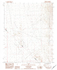
1984 Map of Juniper Mine
USGS Topo · Published 1984About this map
Piute Valley serves as the central focal point for this mid-1980s topographical survey, where the arid desert floor meets the rising terrain of the Newberry Mountains. This borderlands region is defined by the intersection of state and county boundaries, including the Nevada California state line and the junction of Clark and San Bernardino counties. The historical surveying efforts are visible through the marking of the Von Schmidt Line, which reflects the early efforts to delineate these western territories. Industrial and mining activity is evidenced by the namesake Juniper Mine and scattered Prospect locations, supported by infrastructure like the Steel Tower Transmission Line cutting across the valley floor. The map captures a landscape shaped by mineral exploration and the transition from flat alluvial Washes to steep mountain slopes.
Find a feature on this map
10 named features on this map. Tap any name to fly to it.
Don’t see what you’re looking for? This feature index may not catch every label — zoom into the map to look around manually.
Map Details
Editions of this 1984 Juniper Mine Map
This is the sole edition of this map. No revisions or reprints were ever made.
Other maps of this area

1886 · Camp Mohave
USGS Topo · 1:250,000

1892 · Camp Mohave
USGS Topo · 1:250,000

1926 · Mohave City
USGS Topo · 1:96,000

1942 · Camp Mohave
USGS Topo · 1:250,000

1947 · Kingman
USGS Topo · 1:250,000

1948 · Kingman
USGS Topo · 1:250,000

1950 · Davis Dam
USGS Topo · 1:62,500

1952 · Davis Dam
USGS Topo · 1:62,500

1954 · Kingman
USGS Topo · 1:250,000

1955 · Kingman
USGS Topo · 1:250,000