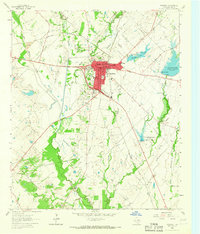
1963 Map of Kaufman
USGS Topo · Published 1965About this map
The Southern Pacific railroad corridor defines the commercial and social heart of Kaufman in the early 1960s, a period when the town functioned as a critical regional hub for transportation and public services. The presence of the County Farm, the State Highway Dept, and a central Kaufman Cemetery near the city core reflects the established civic infrastructure of this county seat. Educational landmarks such as Pyle High Sch and High Sch anchor the residential grid, which transitions into sprawling agricultural lands and creek bottoms to the south.
Find a feature on this map
34 named features on this map. Tap any name to fly to it.
Don’t see what you’re looking for? This feature index may not catch every label — zoom into the map to look around manually.
Map Details
Editions of this 1963 Kaufman Map
This is the sole edition of this map. No revisions or reprints were ever made.
Other maps of this area

1920 · Kemp
USGS Topo · 1:62,500

1954 · Dallas
USGS Topo · 1:250,000

1956 · Kaufman
USGS Topo · 1:62,500

1957 · Kemp
USGS Topo · 1:62,500

1958 · Dallas
USGS Topo · 1:250,000

1960 · Grays Prairie
USGS Topo · 1:24,000

1961 · Kemp
USGS Topo · 1:24,000

1962 · Elmo
USGS Topo · 1:24,000
1962 · Ola
USGS Topo · 1:24,000
1962 · Scurry
USGS Topo · 1:24,000