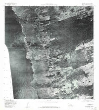
1977 Map of Kealakekua
USGS Topo · Published 1981About this map
Kealakekua and its surrounding coastal settlements are captured here during the late 1970s via high-altitude aerial photography. This orthophotoquad provides a clear visual of the transition from the volcanic shoreline to the upland agricultural and residential belts. The map reveals the development patterns of Kahaluu and Keauhou along the Kona Coast, showing how roads and structures began to hug the rugged terrain. Further inland, the settlements of Holualoa and Honalo sit within a landscape marked by diverse vegetation and property boundaries, reflecting the area's coffee-growing heritage and residential expansion. This specific perspective from 1977 offers researchers a rare look at the exact footprint of buildings and the dense canopy of the Kona forest before modern development intensified.
Find a feature on this map
5 named features on this map. Tap any name to fly to it.
Don’t see what you’re looking for? This feature index may not catch every label — zoom into the map to look around manually.
Map Details
Editions of this 1977 Kealakekua Map
This is the sole edition of this map. No revisions or reprints were ever made.
Other maps of this area

1928 · Kailua
USGS Topo · 1:62,500

1954 · Hawaii South
USGS Topo · 1:250,000

1954 · Hawaii North
USGS Topo · 1:250,000

1959 · Hawaii South
USGS Topo · 1:250,000

1959 · Hawaii North
USGS Topo · 1:250,000

1959 · Hualalai
USGS Topo · 1:24,000

1959 · Honaunau
USGS Topo · 1:24,000

1959 · Puu Lehua
USGS Topo · 1:24,000

1959 · Keahole Point
USGS Topo · 1:24,000

1959 · Kailua
USGS Topo · 1:24,000