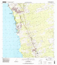
1996 Map of Kealakekua
USGS Topo · Published 1998About this map
Keolonahihi State Historical Park sits along the Kona coast, anchoring a landscape where ancient land divisions meet twentieth-century agricultural and residential development. This mid-1990s survey illustrates the complex ahupuaʻa boundaries that still define the region, including Honalo, Maihi, and Kawanui. The coastal margin is dotted with recreational and historical sites like Pahoehoe Beach Park and White Sands Beach Park, while the upland slopes reflect the area's coffee-growing heritage centered around the Kona Branch Univ of Hawaii Agricultural Experiment Sta. Interior transportation is marked by the historic Judd Trail and Rock Trail, which cut across the volcanic terrain and old lava flows. Settlements such as Kealakekua, Kainaliu, and Holualoa serve as the primary hubs, connected by winding roads that climb from the Pacific Ocean toward the inland heights.
Find a feature on this map
57 named features on this map. Tap any name to fly to it.
Don’t see what you’re looking for? This feature index may not catch every label — zoom into the map to look around manually.
Map Details
Editions of this 1996 Kealakekua Map
This is the sole edition of this map. No revisions or reprints were ever made.
Other maps of this area

1928 · Kailua
USGS Topo · 1:62,500

1954 · Hawaii South
USGS Topo · 1:250,000

1954 · Hawaii North
USGS Topo · 1:250,000

1959 · Hawaii South
USGS Topo · 1:250,000

1959 · Hawaii North
USGS Topo · 1:250,000

1959 · Hualalai
USGS Topo · 1:24,000

1959 · Honaunau
USGS Topo · 1:24,000

1959 · Puu Lehua
USGS Topo · 1:24,000

1959 · Keahole Point
USGS Topo · 1:24,000

1959 · Kailua
USGS Topo · 1:24,000