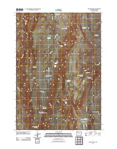
2011 Map of Keeney Ridge
USGS Topo · Published 2011About this map
Keeney Ridge and Hoodoo Ridge dominate this high-desert landscape in eastern Oregon, where a sophisticated network of springs and reservoirs supports seasonal activity. This 2011 survey reveals an intricate water management system for ranching or wildlife, featuring curiously named sites like the Slim and Fatty Reservoir and the Hog Leg Reservoir. The presence of Winter Camp, Indian Camp, and the Sage Hen Pen suggests a landscape utilized for livestock and game management. Smaller drainages like Keeney Creek and Long Creek feed into numerous catchment points, including the Stacey Reservoir Number One and the Freezeout Summit Reservoir. From the heights of Sourdough Mountain to the depths of Daisy Basin, the map documents how water is captured and stored across this arid terrain, accessible primarily via the north-south artery of Freezeout Lake Rd.
Find a feature on this map
34 named features on this map. Tap any name to fly to it.
Don’t see what you’re looking for? This feature index may not catch every label — zoom into the map to look around manually.
Map Details
Editions of this 2011 Keeney Ridge Map
This is the sole edition of this map. No revisions or reprints were ever made.
Other maps of this area

1906 · Mitchell Butte
USGS Topo · 1:125,000

1955 · Boise
USGS Topo · 1:250,000

1958 · Boise
USGS Topo · 1:250,000

1962 · Boise
USGS Topo · 1:250,000

1966 · Harper
USGS Topo · 1:62,500
1967 · Sourdough Spring
USGS Topo · 1:24,000
1967 · Kane Spring Gulch
USGS Topo · 1:24,000

1967 · Twin Springs
USGS Topo · 1:24,000

1972 · Avery Creek
USGS Topo · 1:24,000

1972 · Rufino Butte
USGS Topo · 1:24,000