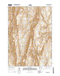
2014 Map of Keeney Ridge
USGS Topo · Published 2014About this map
Keeney Ridge and Freezout Mtn dominate this high-desert landscape in Malheur County, where the map reveals an extensive network of water management features essential for rangeland utility. The terrain is marked by a series of named basins and hollows, including Harper Basin, Snow Basin, and Sand Hollow, which serve as natural catchment areas. A notable concentration of reservoirs with evocative local names, such as Slim and Fatty Reservoir, Hog Leg Reservoir, and Stacey Reservoir Number One, underscores the area's importance for livestock or irrigation. Evidence of long-standing land use is found in labels like Riley Spring and the presence of Freezout Lake Rd, which provides access through the southern reaches of Freezout Basin. To the northeast, the elevation climbs toward Hoodoo Ridge and Hog Leg Reservoir, while the western edge is defined by the steep cuts of Box Canyon and the seasonal flow of Keeney Cr.
Find a feature on this map
40 named features on this map. Tap any name to fly to it.
Don’t see what you’re looking for? This feature index may not catch every label — zoom into the map to look around manually.
Map Details
Editions of this 2014 Keeney Ridge Map
This is the sole edition of this map. No revisions or reprints were ever made.
Other maps of this area

1906 · Mitchell Butte
USGS Topo · 1:125,000

1955 · Boise
USGS Topo · 1:250,000

1958 · Boise
USGS Topo · 1:250,000

1962 · Boise
USGS Topo · 1:250,000

1966 · Harper
USGS Topo · 1:62,500
1967 · Sourdough Spring
USGS Topo · 1:24,000
1967 · Kane Spring Gulch
USGS Topo · 1:24,000

1967 · Twin Springs
USGS Topo · 1:24,000

1972 · Avery Creek
USGS Topo · 1:24,000

1972 · Rufino Butte
USGS Topo · 1:24,000