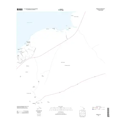
2013 Map of Kiholo
USGS Topo · Published 2013About this map
Volcanic activity and coastal development define this segment of the Island of Hawai‘i. The landscape is dominated by expansive basalt fields, most notably the Lava Flow of 1859 and the Lava Flow of 1801, which have shaped the rugged shoreline from Hou Point to Mano Point. Along the coast, small settlements and coastal resorts like Kukio and Ka‘ūpūlehu are established near natural landmarks such as Kukio Beach and Ka‘ūpūlehu Beach. Further inland, the terrain ascends toward a series of volcanic features including Puu Kolekole and Puu Nahaha. The presence of Wainanali‘i Pond and Keanalele Waterhole near Kiholo highlights the rare freshwater sources found amidst the lava. These features, along with the isolated locations of Poopoomino and Muheenui, illustrate the ongoing human adaptation to the island's dynamic geology.
Find a feature on this map
48 named features on this map. Tap any name to fly to it.
Don’t see what you’re looking for? This feature index may not catch every label — zoom into the map to look around manually.
Map Details
Editions of this 2013 Kiholo Map
This is the sole edition of this map. No revisions or reprints were ever made.
Other maps of this area

1928 · Puako
USGS Topo · 1:62,500

1928 · Kailua
USGS Topo · 1:62,500

1954 · Hawaii North
USGS Topo · 1:250,000

1956 · Puu Hinai
USGS Topo · 1:24,000

1959 · Hawaii North
USGS Topo · 1:250,000

1959 · Kiholo
USGS Topo · 1:24,000

1959 · Hualalai
USGS Topo · 1:24,000
1959 · Anaehoomalu
USGS Topo · 1:24,000

1959 · Makalawena
USGS Topo · 1:24,000

1959 · Keahole Point
USGS Topo · 1:24,000