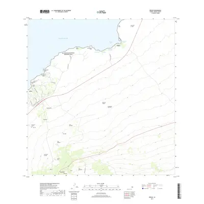
2017 Map of Kiholo
USGS Topo · Published 2017About this map
The coastal lava fields of North Kona are defined by massive volcanic events, including the Lava Flow of 1859 and the earlier Lava Flow of 1801. These geological markers dominate the landscape between the shoreline and the upland regions of Hu'ehu'e and Akahipuu. Along the coast, the Ala Kahakai National Historic Trail follows the rugged Pacific margin, passing landmarks like Mano Point and the waters of Kiholo Bay. Evidence of the area's hydrology is visible at the Keanalele Waterhole and Wainanali'i Pond, which provided critical resources in this arid terrain. Small coastal settlements like Kukio and Kiholo are interspersed with modern developments and landmarks such as the West Hawaii Veterans Cem 1. Numerous volcanic peaks, including Puu Kolekole and Puu Nahaha, rise sharply from the coastline toward the interior of the Island of Hawai'i.
Find a feature on this map
44 named features on this map. Tap any name to fly to it.
Don’t see what you’re looking for? This feature index may not catch every label — zoom into the map to look around manually.
Map Details
Editions of this 2017 Kiholo Map
This is the sole edition of this map. No revisions or reprints were ever made.
Other maps of this area

1928 · Puako
USGS Topo · 1:62,500

1928 · Kailua
USGS Topo · 1:62,500

1954 · Hawaii North
USGS Topo · 1:250,000

1956 · Puu Hinai
USGS Topo · 1:24,000

1959 · Hawaii North
USGS Topo · 1:250,000

1959 · Kiholo
USGS Topo · 1:24,000

1959 · Hualalai
USGS Topo · 1:24,000
1959 · Anaehoomalu
USGS Topo · 1:24,000

1959 · Makalawena
USGS Topo · 1:24,000

1959 · Keahole Point
USGS Topo · 1:24,000