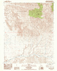
1984 Map of Kingston Peak
USGS Topo · Published 1985About this map
Kingston Peak dominates this high-elevation desert landscape in San Bernardino County, rising from the Kingston Range to overlook a complex network of arid drainage patterns. The topography transitions from the high peaks in the north to the broad, sweeping path of the Kingston Wash in the south. This 1984 provisional survey, compiled from late-1970s aerial photography, highlights the critical water sources of the Mojave, most notably Coyote Holes. These features were historically vital for travelers and livestock navigating the arid corridor between mountain ranges. The map provides a precise look at the township and range system, including t19n, t18n, and r9e, which governed the surveying of this remote terrain.
Find a feature on this map
6 named features on this map. Tap any name to fly to it.
Don’t see what you’re looking for? This feature index may not catch every label — zoom into the map to look around manually.
Map Details
Editions of this 1984 Kingston Peak Map
This is the sole edition of this map. No revisions or reprints were ever made.
Other maps of this area

1910 · Ivanpah
USGS Topo · 1:250,000

1912 · Ivanpah
USGS Topo · 1:250,000

1933 · Avawatz Mountains
USGS Topo · 1:250,000

1942 · Ivanpah
USGS Topo · 1:250,000

1947 · Trona
USGS Topo · 1:250,000

1947 · Kingman
USGS Topo · 1:250,000

1948 · Kingman
USGS Topo · 1:250,000

1948 · Trona
USGS Topo · 1:250,000

1950 · Tecopa
USGS Topo · 1:62,500

1951 · Tecopa
USGS Topo · 1:62,500