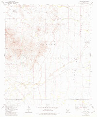
1981 Map of Kohatk
USGS Topo · Published 1981About this map
The desert landscape of the Papago Indian Reservation defines this 1981 survey, where the dry expanse of the Santa Rosa Valley meets the rising terrain of the Vekol Mountains. Mining activity is a prominent feature of the mountain slopes, with several named operations including the Christmas Gift Mine, Reward Mine, and Red Chief Mine dotting the hillsides. These sites, along with the Hill Top Mine, suggest a history of prospecting in the mineral-rich ranges of Pinal and Pima counties.
Find a feature on this map
18 named features on this map. Tap any name to fly to it.
Don’t see what you’re looking for? This feature index may not catch every label — zoom into the map to look around manually.
Map Details
Editions of this 1981 Kohatk Map
This is the sole edition of this map. No revisions or reprints were ever made.
Other maps of this area

1934 · Silver Bell
USGS Topo · 1:125,000

1941 · Vekol Mountains
USGS Topo · 1:62,500

1942 · Silver Reef Mountains
USGS Topo · 1:62,500

1942 · Vekol Mountains
USGS Topo · 1:62,500

1953 · Ajo
USGS Topo · 1:250,000

1956 · Tucson
USGS Topo · 1:250,000

1957 · Ajo
USGS Topo · 1:250,000

1958 · Ajo
USGS Topo · 1:250,000

1958 · Tucson
USGS Topo · 1:250,000

1959 · Tucson
USGS Topo · 1:250,000