2023 Map of La Fargeville
USGS Topo · Published 2023About this map
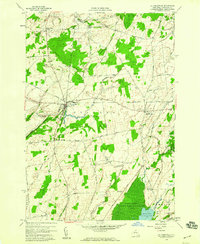
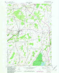
La Fargeville serves as the central hub of this Jefferson County landscape, situated where the Chaumont River meets several regional roads including Co Rte 181 and Plank Rd. The settlement pattern follows a series of historic corridors, connecting smaller hamlets like Orleans Four Corners and Depauville across a terrain defined by subtle rises such as Beech Ridge and Dog Hill. Genealogists will find a high density of burial sites throughout the township, including Saint Johns Cem, Beech Ridge Cem, and the New Boston Cem near the eastern border. The hydrology of the area is complex, with Black Creek, Carter Creek, and Stone Mills Creek draining the agricultural flats between Buttermilk Flats Rd and Honey Flats Rd. This modern survey documents the persistent rural character of the region, where older local routes like Whiskey St and Tanners Corners Rd still provide the primary framework for the community.
Find a feature on this map
51 named features on this map. Tap any name to fly to it.
Don’t see what you’re looking for? This feature index may not catch every label — zoom into the map to look around manually.
Map Details
Editions of this 2023 La Fargeville Map
This is the sole edition of this map. No revisions or reprints were ever made.
Historical Maps of Pamelia Through Time
3 maps found