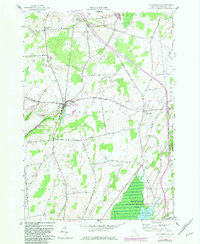
1982 Map of La Fargeville
USGS Topo · Published 1983About this map
La Fargeville serves as the primary hub of this Jefferson County landscape, situated at the confluence of the Chaumont River and several local transit corridors. The 1982 photorevisions highlight modern infrastructure updates, such as a Sewage Disposal plant and a Landing Strip, superimposed over a traditional dairy and agricultural layout. The terrain is characterized by gentle elevations like Beech Ridge and Dog Hill, with numerous family-named crossroads like Tanners Corners and De La Farge Corners anchoring the rural road network.
Find a feature on this map
44 named features on this map. Tap any name to fly to it.
Don’t see what you’re looking for? This feature index may not catch every label — zoom into the map to look around manually.
Map Details
Editions of this 1982 La Fargeville Map
This is the sole edition of this map. No revisions or reprints were ever made.
Other maps of this area

1900 · Clayton
USGS Topo · 1:62,500

1903 · Grindstone
USGS Topo · 1:62,500

1903 · Clayton
USGS Topo · 1:62,500

1903 · Alexandria Bay
USGS Topo · 1:62,500

1903 · Theresa
USGS Topo · 1:62,500

1942 · Clayton
USGS Topo · 1:24,000
1943 · Dexter
USGS Topo · 1:31,680

1943 · Thousand Island Park
USGS Topo · 1:31,680

1943 · Redwood
USGS Topo · 1:31,680

1943 · Clayton
USGS Topo · 1:31,680