
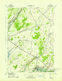
1943 Map of Clayton
USGS Topo · Published 1943About this map
Clayton sits at the northern edge of this wartime survey, serving as a gateway to the St Lawrence River and its scattered landforms like Calumet Island and Washington I. The landscape is defined by the heavy presence of the New York Central railroad, which terminates at the riverfront to support the regional commerce of the early 1940s. Moving inland, the map transitions into a dense network of rural school districts and family landmarks. Researchers can identify School No 14 and School No 7 along the roads leading toward Clayton Center. To the south, Depauville marks a significant settlement at the crossing of the Chaumont River, where the terrain begins to flatten. The distribution of small burial grounds like Corbin Cem and Weaver Cem reflects the deep-rooted family farming history of Jefferson County during this era.
Find a feature on this map
26 named features on this map. Tap any name to fly to it.
Don’t see what you’re looking for? This feature index may not catch every label — zoom into the map to look around manually.
Map Details
Editions of this 1943 Clayton Map
This is the sole edition of this map. No revisions or reprints were ever made.
Other maps of this area

1900 · Clayton
USGS Topo · 1:62,500

1903 · Grindstone
USGS Topo · 1:62,500

1903 · Clayton
USGS Topo · 1:62,500

1903 · Alexandria Bay
USGS Topo · 1:62,500

1903 · Theresa
USGS Topo · 1:62,500

1942 · Chaumont
USGS Topo · 1:31,680

1942 · Sawmill Bay
USGS Topo · 1:31,680

1942 · Clayton
USGS Topo · 1:24,000
1943 · Dexter
USGS Topo · 1:31,680

1943 · Thousand Island Park
USGS Topo · 1:31,680