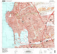
1996 Map of La Jolla
USGS Topo · Published 2000About this map
La Jolla Bay and the surrounding coastal bluffs anchor this mid-1990s survey of one of Southern California's most distinct residential and institutional landscapes. The map captures the dense suburban expansion between the Pacific Ocean and Miramar Marine Corps Air Station, tracing the growth of Clairemont, University City, and Linda Vista along the corridors of the San Diego Freeway. High-density educational and research footprints are prominent, from the University of California San Diego and the Scripps Institution of Oceanography in the north to the University of San Diego overlooking the San Diego River valley.
Find a feature on this map
121 named features on this map. Tap any name to fly to it.
Don’t see what you’re looking for? This feature index may not catch every label — zoom into the map to look around manually.
Map Details
Editions of this 1996 La Jolla Map
This is the sole edition of this map. No revisions or reprints were ever made.
Other maps of this area

1903 · La Jolla
USGS Topo · 1:62,500

1904 · San Diego
USGS Topo · 1:62,500

1904 · Southern California Sheet No. 2
USGS Topo · 1:250,000

1930 · La Jolla
USGS Topo · 1:62,500

1930 · San Diego
USGS Topo · 1:62,500

1942 · Poway Valley
USGS Topo · 1:31,680
1942 · La Mesa
USGS Topo · 1:31,680

1942 · Point Loma
USGS Topo · 1:31,680
1943 · Del Mar
USGS Topo · 1:31,680

1943 · La Jolla
USGS Topo · 1:31,680