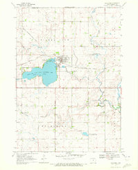
1970 Map of Lake Park
USGS Topo · Published 1972About this map
Lake Park stands as the primary hub of this northwestern Iowa landscape, positioned at the northern tip of Silver Lake where the Chicago Rock Island and Pacific railroad cuts through the heart of town. The area is defined by its glacial lakes and extensive conservation lands, including the Silver Lake State Game Management Area and Trappers Bay State Park. This 1970s record shows the town’s infrastructure, from the Sewage Disposal Ponds to the Boat Ramp, during a period of established lakeside recreation and agriculture.
Find a feature on this map
22 named features on this map. Tap any name to fly to it.
Don’t see what you’re looking for? This feature index may not catch every label — zoom into the map to look around manually.
Map Details
Editions of this 1970 Lake Park Map
This is the sole edition of this map. No revisions or reprints were ever made.
Other maps of this area

1954 · Fairmont
USGS Topo · 1:250,000

1958 · Fairmont
USGS Topo · 1:250,000

1960 · Round Lake
USGS Topo · 1:24,000

1960 · Sioux Valley
USGS Topo · 1:24,000

1970 · Milford
USGS Topo · 1:24,000

1970 · Lakefield SW
USGS Topo · 1:24,000

1970 · Okoboji
USGS Topo · 1:24,000

1970 · Lake Park SE
USGS Topo · 1:24,000

1970 · May City
USGS Topo · 1:24,000

1970 · Harris
USGS Topo · 1:24,000