Loading...
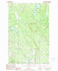
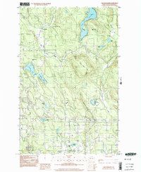
Loading map...1989 Map of Lake Roesiger
USGS Topo · Published 1989About this map
Lake Roesiger serves as the central focal point of this Snohomish County landscape during the late 1980s. The region is defined by a dense network of glacial lakes and shifting timberlands, where small residential clusters like Forest Glade and Wagner sit amidst an intricate drainage system. Waterways such as Woods Creek and its tributaries, West Fork Woods Creek and Roesiger Creek, carve through the terrain surrounding Three Lakes Hill.
Find a feature on this map
26 named features on this map. Tap any name to fly to it.
Don’t see what you’re looking for? This feature index may not catch every label — zoom into the map to look around manually.
Map Details
Date Portrayed1989
Date Published1989
PublisherU.S. Geological Survey
Map TypeTopographic
Scale1:24000
Physical Dimensions22.2 x 27 inches
Editions of this 1989 Lake Roesiger Map
This is the sole edition of this map. No revisions or reprints were ever made.
Historical Maps of Everett Through Time
3 maps found

Featured Locations
Source Details
SourceU.S. Geological Survey
CopyrightPublic Domain