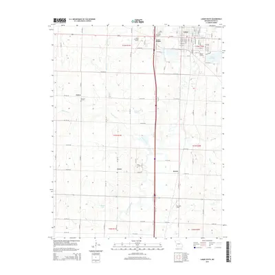
2015 Map of Lamar South
USGS Topo · Published 2015About this map
Lamar anchors the northern portion of this map, appearing as a developed grid of streets such as W 7th St and E Central Rd. The surrounding Barton County landscape is defined by the headwaters and branches of the North Fork Spring River, which winds south through the center of the sheet. Small agricultural communities and named crossroads like Oakton, Esrom, and Boston dot the rural sections, illustrating the distributed settlement pattern common to this part of Missouri.
Find a feature on this map
52 named features on this map. Tap any name to fly to it.
Don’t see what you’re looking for? This feature index may not catch every label — zoom into the map to look around manually.
Map Details
Editions of this 2015 Lamar South Map
This is the sole edition of this map. No revisions or reprints were ever made.
Other maps of this area

1886 · Nevada
USGS Topo · 1:125,000

1886 · Carthage
USGS Topo · 1:125,000

1894 · Nevada
USGS Topo · 1:125,000

1894 · Carthage
USGS Topo · 1:125,000

1947 · Joplin
USGS Topo · 1:250,000

1949 · Joplin
USGS Topo · 1:250,000

1954 · Joplin
USGS Topo · 1:250,000

1958 · Joplin
USGS Topo · 1:250,000

1959 · Joplin
USGS Topo · 1:250,000
1962 · Kenoma
USGS Topo · 1:24,000