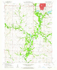
1962 Map of Lamar South
USGS Topo · Published 1964About this map
The Lamar City street grid and the nearby Lamar Heights expansion define the northern edge of this Barton County survey. Settled along the North Fork Spring River, the area shows a transition from the urban center to the surrounding agricultural prairie. Significant rural infrastructure is recorded through a network of one-room schoolhouses and community landmarks, such as the Rose Branch Sch, Pleasant Hill Sch, and the Forest Grove Ch.
Find a feature on this map
36 named features on this map. Tap any name to fly to it.
Don’t see what you’re looking for? This feature index may not catch every label — zoom into the map to look around manually.
Map Details
Editions of this 1962 Lamar South Map
This is the sole edition of this map. No revisions or reprints were ever made.
Other maps of this area

1886 · Nevada
USGS Topo · 1:125,000

1886 · Carthage
USGS Topo · 1:125,000

1894 · Nevada
USGS Topo · 1:125,000

1894 · Carthage
USGS Topo · 1:125,000

1947 · Joplin
USGS Topo · 1:250,000

1949 · Joplin
USGS Topo · 1:250,000

1954 · Joplin
USGS Topo · 1:250,000

1958 · Joplin
USGS Topo · 1:250,000

1959 · Joplin
USGS Topo · 1:250,000
1962 · Kenoma
USGS Topo · 1:24,000