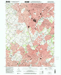
1999 Map of Lansdale
USGS Topo · Published 2001About this map
Lansdale and its surrounding townships in Montgomery County exhibit a dense suburban landscape at the close of the millennium, defined by a complex intersection of major transportation corridors and established residential communities. The Pennsylvania Turnpike Northeast Extension carves through the terrain, linking settlements like Kulpsville and West Point to the broader regional network. The Septa rail line remains a vital artery, serving commuters at Pennbrook Station as it passes through North Wales and Gwynedd Valley.
Find a feature on this map
87 named features on this map. Tap any name to fly to it.
Don’t see what you’re looking for? This feature index may not catch every label — zoom into the map to look around manually.
Map Details
Editions of this 1999 Lansdale Map
This is the sole edition of this map. No revisions or reprints were ever made.
Other maps of this area

1888 · Quakertown
USGS Topo · 1:62,500

1890 · Doylestown
USGS Topo · 1:62,500

1890 · Quakertown
USGS Topo · 1:62,500

1891 · Doylestown
USGS Topo · 1:62,500

1893 · Germantown
USGS Topo · 1:62,500

1894 · Quakertown
USGS Topo · 1:62,500

1894 · Norristown
USGS Topo · 1:62,500

1894 · Germantown
USGS Topo · 1:62,500

1895 · Norristown
USGS Topo · 1:62,500

1896 · Germantown
USGS Topo · 1:62,500