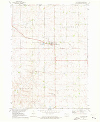
1971 Map of Larchwood
USGS Topo · Published 1973About this map
The town of Larchwood serves as the central hub for this corner of Lyon County, Iowa, sitting just south of the Minnesota border and east of the South Dakota line. In the early 1970s, the landscape was defined by a grid of rural roads and agricultural plots, punctuated by local landmarks such as West Lyon Sch and the Zangger Airport. This survey provides a clear view of the area's social fabric, documented through the Larchwood Cem and St Marys Cem, which mark the community's heritage. The northern part of the map is traversed by a watercourse labeled simply as Blood, which flows through the Sioux and Larchwood townships. Small-scale industrial activity is evidenced by a Gravel Pit near the river, while the presence of Sewage Disposal Ponds near the town center indicates the municipal infrastructure supporting the local population during this era.
Find a feature on this map
19 named features on this map. Tap any name to fly to it.
Don’t see what you’re looking for? This feature index may not catch every label — zoom into the map to look around manually.
Map Details
Editions of this 1971 Larchwood Map
This is the sole edition of this map. No revisions or reprints were ever made.
Other maps of this area

1897 · Canton
USGS Topo · 1:125,000

1900 · Canton
USGS Topo · 1:125,000

1955 · Sioux Falls
USGS Topo · 1:250,000

1958 · Sioux Falls
USGS Topo · 1:250,000

1962 · Klondike
USGS Topo · 1:24,000

1962 · Canton
USGS Topo · 1:24,000

1962 · Brandon
USGS Topo · 1:24,000

1967 · Valley Springs
USGS Topo · 1:24,000

1967 · Hills
USGS Topo · 1:24,000

1971 · Lester
USGS Topo · 1:24,000