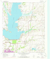
1963 Map of Lavon
USGS Topo · Published 1978About this map
Lake Lavon dominates this Collin County landscape, its expansive waters and intricate shoreline shaping the growth of nearby residential developments like Lavon Beach Estates and Yucote Acres. The map documents a period of significant hydraulic management in North Texas, centered on the Lavon Dam and its role in regulating the Trinity River watershed. Below the dam, the terrain transitions into agricultural and industrial zones, marked by several Quarries and the northern reaches of Lake Ray Hubbard.
Find a feature on this map
40 named features on this map. Tap any name to fly to it.
Don’t see what you’re looking for? This feature index may not catch every label — zoom into the map to look around manually.
Map Details
Editions of this 1963 Lavon Map
Other maps of this area

1891 · Dallas
USGS Topo · 1:125,000

1893 · Dallas
USGS Topo · 1:125,000

1912 · Rockwall
USGS Topo · 1:31,680

1919 · Royse City
USGS Topo · 1:62,500

1924 · Farmersville 3-c
USGS Topo · 1:48,000

1924 · Mc Kinney 4-d
USGS Topo · 1:48,000

1929 · McKinney
USGS Topo · 1:62,500

1930 · Farmersville
USGS Topo · 1:62,500

1954 · Dallas
USGS Topo · 1:250,000

1954 · Sherman
USGS Topo · 1:250,000