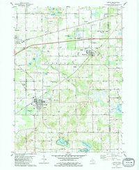
1981 Map of Lawton
USGS Topo · Published 1982About this map
The glacial landscape of Van Buren County is defined here by a chain of water bodies, including Huzzy Lake, Little Bankson Lake, and Ackley Lake. At the center of this 1981 survey, the village of Lawton serves as a local hub, with its grid extending toward Brine Ponds and the Amtrak rail line. To the northeast, Mattawan shows significant development near the Mattawan Airpark, while the surrounding rural townships are dotted with family-named landmarks and heritage sites such as Harwick Cem and Oak Grove Cem.
Find a feature on this map
72 named features on this map. Tap any name to fly to it.
Don’t see what you’re looking for? This feature index may not catch every label — zoom into the map to look around manually.
Map Details
Editions of this 1981 Lawton Map
This is the sole edition of this map. No revisions or reprints were ever made.
Other maps of this area

1916 · Kalamazoo
USGS Topo · 1:62,500

1918 · Kalamazoo
USGS Topo · 1:62,500

1922 · Schoolcraft
USGS Topo · 1:62,500

1943 · Kalamazoo
USGS Topo · 1:62,500

1943 · Schoolcraft
USGS Topo · 1:62,500

1944 · Marcellus
USGS Topo · 1:62,500

1946 · Marcellus
USGS Topo · 1:62,500

1946 · Gobles
USGS Topo · 1:62,500

1948 · Gobles
USGS Topo · 1:62,500

1949 · Gobles
USGS Topo · 1:62,500