2023 Map of Leeds
USGS Topo · Published 2023About this map
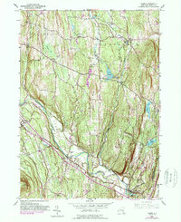
Catskill Creek winds through a landscape of established hamlets and family burial grounds in this modern-day record of Greene County. The settlement of Leeds sits near the Leeds Flat, characterized by its proximity to Jefferson Heights and the historical Leeds Village Cem. Moving northwest, the terrain rises toward Potic Mountain and Indian Ridge, separating the drainage of Potic Creek from the plains to the west. Family-named cemeteries like Waldron Cem, Brandow Cem, and Webber Cem are scattered across the uplands, providing a roadmap of local lineage. The presence of the Catskill Valley Airpark near South Cairo and the Sandy Plain illustrates the modern transport infrastructure alongside older agricultural foundations at Gayhead and Result.
Find a feature on this map
143 named features on this map. Tap any name to fly to it.
Don’t see what you’re looking for? This feature index may not catch every label — zoom into the map to look around manually.
Map Details
Editions of this 2023 Leeds Map
This is the sole edition of this map. No revisions or reprints were ever made.