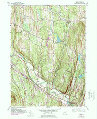
1953 Map of Leeds
USGS Topo · Published 1989About this map
Indian Ridge and the Catskill Mountains dominate this mid-century landscape in Greene County, where the topography transitions from the high peaks of Cairo Round Top down to the Flat near the village of Leeds. The map documents a significant network of family and community burial grounds, such as the Waldron-Brandow Cem, Honey Hollow Cem, and Sandy Plain Cem, which provide essential geographic anchors for genealogical research. Water resources are central to the area's development, with Potuck Reservoir and its associated Filtration Plant situated alongside Potuck Creek. Transportation patterns are clearly defined by the winding course of Catskill Creek, which is spanned by the Leeds Bridge, and the small Sport Haven Airport near Cairo. The 1980s purple revisions highlight modernization in settlements like Cairo Junction and Limestreet against the backdrop of established townships like Greenville and Coxsackie.
Find a feature on this map
43 named features on this map. Tap any name to fly to it.
Don’t see what you’re looking for? This feature index may not catch every label — zoom into the map to look around manually.
Map Details
Editions of this 1953 Leeds Map
4 editions found
Other maps of this area

1892 · Kaaterskill
USGS Topo · 1:62,500

1893 · Kaaterskill
USGS Topo · 1:62,500

1893 · Coxsackie
USGS Topo · 1:62,500

1893 · Durham
USGS Topo · 1:62,500

1894 · Coxsackie
USGS Topo · 1:62,500

1894 · Kaaterskill
USGS Topo · 1:62,500

1894 · Durham
USGS Topo · 1:62,500

1895 · Catskill
USGS Topo · 1:62,500

1899 · Kaaterskill
USGS Topo · 1:62,500

1903 · Kaaterskill
USGS Topo · 1:62,500