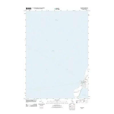
2011 Map of Leland
USGS Topo · Published 2011About this map
Leland occupies a narrow strip of land between two distinct water bodies, serving as a maritime gateway on the Leelanau Peninsula. This 2011 survey illustrates the settlement's reliance on both Lake Michigan and the northern tip of Lake Leelanau, which are separated by a small channel near Carp River Point. The community's character as a working harbor and transit hub is evident through the inclusion of the Manitou Island Ferry and the Manitou Mail Boat Deck, essential links for the offshore islands. Local landmarks such as the Leland Yacht Harbor and the Leland Post Office anchor the town center, while the Leland Catholic Cemetery provides a point of interest for those researching local family histories. The residential layout is represented by several streets including S Lake ST and Oxford DR, showing the modern footprint of this coastal village.
Find a feature on this map
12 named features on this map. Tap any name to fly to it.
Don’t see what you’re looking for? This feature index may not catch every label — zoom into the map to look around manually.
Map Details
Editions of this 2011 Leland Map
This is the sole edition of this map. No revisions or reprints were ever made.
Other maps of this area

1954 · Traverse City
USGS Topo · 1:250,000

1955 · Cheboygan
USGS Topo · 1:250,000

1957 · Traverse City
USGS Topo · 1:62,500

1957 · Northport
USGS Topo · 1:62,500

1957 · Maple City
USGS Topo · 1:62,500

1958 · Cheboygan
USGS Topo · 1:250,000

1958 · Traverse City
USGS Topo · 1:250,000
1983 · Northport NW
USGS Topo · 1:25,000
1983 · Gills Pier
USGS Topo · 1:25,000

1983 · Traverse City
USGS Topo · 1:100,000