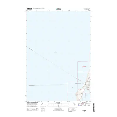
2014 Map of Leland
USGS Topo · Published 2014About this map
Leland sits at the vital junction where the Leland River connects the waters of Lake Leelanau to the vast expanse of Lake Michigan. This 2014 survey captures the coastal character of the Leelanau Peninsula, highlighting the nautical connections essential to the area's identity. Mapping of the Leelanau-North Manitou Island Fry and Leelanau-South Manitou Island Fry underscores the community's role as a primary gateway to the Manitou Islands. Local landmarks such as the Leland Catholic Cem and Carp River Point provide specific geographic anchors for genealogists and local historians. The street grid, including N Lake St and S Grand Ave, reveals the concentrated development of this historic lakeside settlement nestled between two significant bodies of water.
Find a feature on this map
27 named features on this map. Tap any name to fly to it.
Don’t see what you’re looking for? This feature index may not catch every label — zoom into the map to look around manually.
Map Details
Editions of this 2014 Leland Map
This is the sole edition of this map. No revisions or reprints were ever made.
Other maps of this area

1954 · Traverse City
USGS Topo · 1:250,000

1955 · Cheboygan
USGS Topo · 1:250,000

1957 · Traverse City
USGS Topo · 1:62,500

1957 · Northport
USGS Topo · 1:62,500

1957 · Maple City
USGS Topo · 1:62,500

1958 · Cheboygan
USGS Topo · 1:250,000

1958 · Traverse City
USGS Topo · 1:250,000
1983 · Northport NW
USGS Topo · 1:25,000
1983 · Gills Pier
USGS Topo · 1:25,000

1983 · Traverse City
USGS Topo · 1:100,000