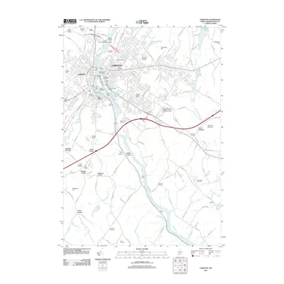
2011 Map of Lewiston
USGS Topo · Published 2011About this map
The Androscoggin River serves as the industrial and geographic spine of this Maine twin-city region, where the legacy of textile manufacturing is preserved through massive structures like the Bates Mill and Androscoggin Mill. These sites, along with the Barker Mill Dam and Lewiston Falls Dam, reflect a landscape deeply shaped by water power. Surrounding the urban cores of Lewiston and Auburn, the terrain is punctuated by significant heights such as Mount David and Thorncrag Hill, while the outlying areas reveal a dense network of smaller corners and junctions. Genealogists will find a high concentration of burial sites, ranging from the expansive Gracelawn Memorial Park to smaller, family-named plots like Briggs Cemetery and McKenney Cemetery. The map also captures the academic presence of the Lewiston-Auburn College-University of Southern Maine and the vital modern infrastructure of the Vietnam Veterans Memorial Bridge.
Find a feature on this map
136 named features on this map. Tap any name to fly to it.
Don’t see what you’re looking for? This feature index may not catch every label — zoom into the map to look around manually.
Map Details
Editions of this 2011 Lewiston Map
This is the sole edition of this map. No revisions or reprints were ever made.
Other maps of this area

1892 · Freeport
USGS Topo · 1:62,500

1894 · Gray
USGS Topo · 1:62,500

1898 · Gray
USGS Topo · 1:62,500

1908 · Poland
USGS Topo · 1:62,500

1908 · Lewiston
USGS Topo · 1:62,500

1940 · Poland
USGS Topo · 1:62,500

1941 · Freeport
USGS Topo · 1:62,500

1942 · Lewiston
USGS Topo · 1:62,500

1942 · Poland
USGS Topo · 1:62,500

1942 · Gray
USGS Topo · 1:62,500