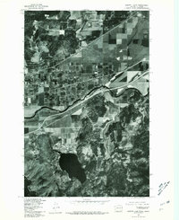
1978 Map of Liberty Lake
USGS Topo · Published 1981About this map
Liberty Lake and the winding course of the Spokane River define the terrain of this 1978 orthophotoquad, captured at a moment of significant suburban expansion between Washington and Idaho. The aerial imagery, processed by the Geological Survey in cooperation with the State of Washington Department of Natural Resources, reveals the distinct grid patterns of developing residential tracts and agricultural fields. The small settlement of Moab sits at a strategic crossing point of transportation corridors, while the eponymous Liberty Lake serves as a clear focal point for local settlement. Unlike traditional line-drawn maps, this orthophotograph preserves the exact visual state of the landscape, showing individual woodlots, orchards, and the precise shoreline of the lake during the late 1970s. This provides a rare visual record for tracing property boundaries and land-use shifts in the Inland Northwest.
Find a feature on this map
4 named features on this map. Tap any name to fly to it.
Don’t see what you’re looking for? This feature index may not catch every label — zoom into the map to look around manually.
Map Details
Editions of this 1978 Liberty Lake Map
This is the sole edition of this map. No revisions or reprints were ever made.
Other maps of this area

1901 · Spokane
USGS Topo · 1:125,000

1903 · Rathdrum
USGS Topo · 1:125,000

1943 · Mt Spokane
USGS Topo · 1:62,500

1949 · Greenacres
USGS Topo · 1:62,500

1950 · Mt Spokane
USGS Topo · 1:62,500

1951 · Greenacres
USGS Topo · 1:62,500

1955 · Spokane
USGS Topo · 1:250,000

1957 · Coeur D'Alene
USGS Topo · 1:62,500

1958 · Spokane
USGS Topo · 1:250,000

1961 · Rathdrum
USGS Topo · 1:24,000