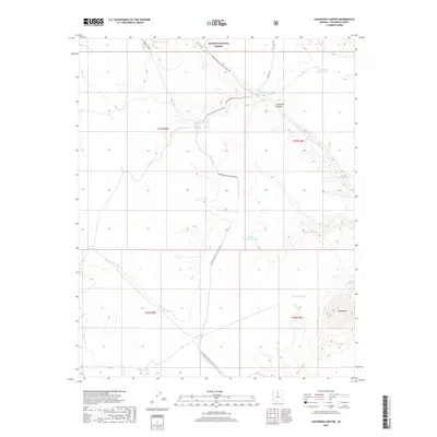
2018 Map of Lockwood Canyon
USGS Topo · Published 2018About this map
Kaibab National Forest dominates this Coconino County landscape, where the high-country terrain is defined by its network of water catchments and long-distance trails. The Arizona National Scenic Trail meanders through the center of the sheet, providing a corridor for travelers through the high desert and woodlands. This 2018 survey reveals the critical importance of water management in the region, documented through numerous named "tanks" or reservoirs such as Pearl Harbor Tank, Dent and Sayer Tank, and Raymond Tank. The topography is marked by significant natural landmarks including the namesake Lockwood Canyon and the prominent Mesa Butte in the southeast corner. Local access is facilitated by a grid of forest service roads, including Fire RD 2741 and the historical alignment of Old "301" Rd., which illustrate the administrative and recreational use of this protected federal land.
Find a feature on this map
23 named features on this map. Tap any name to fly to it.
Don’t see what you’re looking for? This feature index may not catch every label — zoom into the map to look around manually.
Map Details
Editions of this 2018 Lockwood Canyon Map
This is the sole edition of this map. No revisions or reprints were ever made.
Other maps of this area

1886 · San Francisco Mtns
USGS Topo · 1:250,000

1891 · San Francisco Mtns
USGS Topo · 1:250,000

1894 · San Francisco Mtns
USGS Topo · 1:250,000

1899 · San Francisco Mtns
USGS Topo · 1:250,000

1947 · Flagstaff
USGS Topo · 1:250,000

1954 · Flagstaff
USGS Topo · 1:250,000

1958 · Flagstaff
USGS Topo · 1:250,000

1960 · Flagstaff
USGS Topo · 1:250,000
1960 · Ebert Mtn
USGS Topo · 1:62,500

1962 · Flagstaff
USGS Topo · 1:250,000