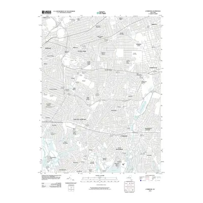
2010 Map of Lynbrook
USGS Topo · Published 2010About this map
Belmont Park and the sprawling campus of Adelphi University anchor this dense suburban corridor along the border of Queens and Nassau County. The landscape is characterized by a high concentration of established community institutions, including an extensive cemetery belt featuring Beth David Cemetery, Montefiore Cemetery, and Maimonides-Elmont Cemetery. In the south, the terrain transitions into the complex wetlands and tidal channels of Hewlett Bay and Head of Bay, where Thurston Basin and Macy Channel define the coastal edge. Residential growth is reflected in the numerous local postal hubs like the Franklin Square Post Office and Lynbrook Post Office. Amidst this late-twentieth-century development, traditional land uses like Grossmann's Farm and Dee's Nursery remain visible, providing evidence of the area's agricultural past before it was fully integrated into the metropolitan expanse. Major transit arteries such as the Southern State Pkwy and Cross Island Pkwy weave these diverse neighborhoods together.
Find a feature on this map
115 named features on this map. Tap any name to fly to it.
Don’t see what you’re looking for? This feature index may not catch every label — zoom into the map to look around manually.
Map Details
Editions of this 2010 Lynbrook Map
This is the sole edition of this map. No revisions or reprints were ever made.
Other maps of this area

1889 · Brooklyn
USGS Topo · 1:62,500

1891 · Brooklyn
USGS Topo · 1:62,500

1891 · Harlem
USGS Topo · 1:62,500

1897 · Harlem
USGS Topo · 1:62,500

1897 · Brooklyn
USGS Topo · 1:62,500

1897 · Hempstead
USGS Topo · 1:62,500

1897 · Oyster Bay
USGS Topo · 1:62,500

1898 · Harlem
USGS Topo · 1:62,500

1898 · Hempstead
USGS Topo · 1:62,500

1898 · Brooklyn
USGS Topo · 1:62,500