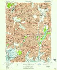
1954 Map of Lynbrook
USGS Topo · Published 1964About this map
The dense suburban expansion of western Long Island is evident in this mid-century survey, which documents the complex border between Queens and Nassau counties. Post-war growth is anchored by major institutional and recreational landmarks, including the sprawling grounds of Creedmore State Hospital and the iconic Belmont Park. The residential fabric of communities like Floral Park, Garden City, and Valley Stream is tightly woven around established transportation corridors such as the Long Island RR and the Southern State Parkway. In the eastern section, the educational and spiritual landscape is defined by Adelphi College and the Cathedral of the Incarnation. The map also captures the critical role of water management and open space in this developed region, from the wetlands around Hempstead Lake and Smith Pond to the southern tidal inlets of Hewlett Bay.
Find a feature on this map
132 named features on this map. Tap any name to fly to it.
Don’t see what you’re looking for? This feature index may not catch every label — zoom into the map to look around manually.
Map Details
Editions of this 1954 Lynbrook Map
2 editions found
Other maps of this area

1889 · Brooklyn
USGS Topo · 1:62,500

1891 · Brooklyn
USGS Topo · 1:62,500

1891 · Harlem
USGS Topo · 1:62,500

1897 · Harlem
USGS Topo · 1:62,500

1897 · Brooklyn
USGS Topo · 1:62,500

1897 · Hempstead
USGS Topo · 1:62,500

1897 · Oyster Bay
USGS Topo · 1:62,500

1898 · Harlem
USGS Topo · 1:62,500

1898 · Hempstead
USGS Topo · 1:62,500

1898 · Brooklyn
USGS Topo · 1:62,500